
Exton Park is run as a traditional country estate and has the remains of an extensive deer park and woodland, as well as gardens around the house. The park was landscaped in the 18th century and also contains 19th-century features, including the ruins of the original Tudor mansion.
- Brief History
The park has medieval origins. Features date from the late-17th century through to the 19th century.
- Walled Kitchen Garden
The precise dating of the kitchen garden walls is unknown but the first cartographic reference is the OS first Edition 1884 (Rutland V SE) map, which shows a large garden, walled on three sides, with extensive glass and brick structures.
The first written reference to kitchen garden walls is an entry in the The Gardener’s Magazine of 1829. This account refers to “the walls of the kitchen-garden … and the ruins of a hot-house, built in the Dutch style, with oak rafters of ample dimensions” – although the locations are not made clear.
The Exton Archive contains a sketch plan of the pleasure grounds by James Edmund Harries, dated 1843. This shows a walled kitchen garden in its current form, size and location, but with no associated buildings or glasshouses.
The walled kitchen garden (WKG) lies 600m to the NW of the Hall alongside a fishpond which forms its southern boundary. It is around 7 acres in size with a roughly square outline with one corner cut across at the north western end to accommodate the old glasshouses on the S facing side with bothies behind.
Overall dimensions are 150m E-W and 100m N-S. The area is currently grassed with some fruit trees to the NW corner. Some of the original paths remain but the glasshouses were demolished in 1999.
The enclosed ground is generally flat but with gentle slope N-S.Currently the area is laid to grass for “glamping”, run by a company called Lantern & Larks, although a few remaining fruit trees are maintained.

Extract from the 1884 1st edition OS map 
Aerial photograph 1952 
External view of north wall and earlier frame yard 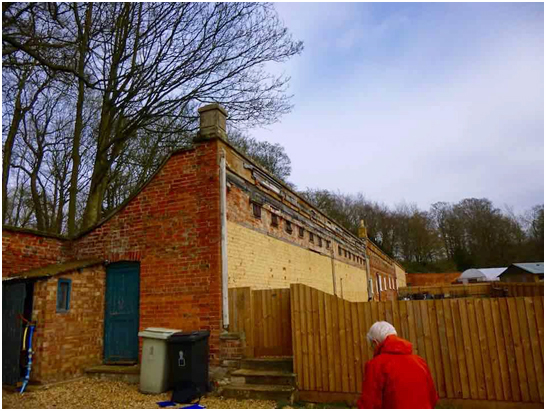
View of south facing wall with bothies behind– showing ventilator flaps 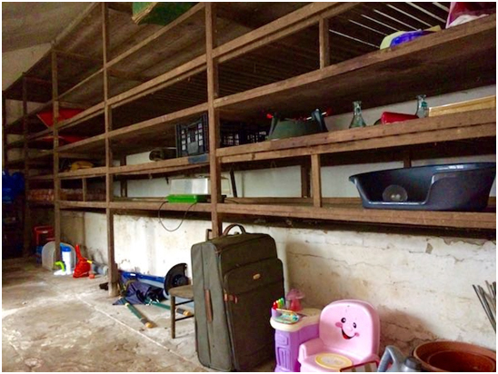
Storage racks in the fruit room See our full research report on the Walled Kitchen Garden here:
Exton Hall, Exton
- Detailed Description
The following is from the Register of Parks and Gardens of Special Historic Interest. For the most up-to-date Register entry, please visit the The National Heritage List for England (NHLE):
Gardens and an extensive park, the latter with medieval origins and with probably later 17th-century as well as late 18th- and 19th-century features and buildings, associated with a country house.
Location, Area, Boundaries, Landform, Setting
Exton Park stands in its grounds west of Exton village. This lies 7km east of Oakham, on local roads north of the A606 from Oakham to Stamford. The east, south and west sides of what is here termed the inner park are bounded by roads, the last extending north to bound the whole of the west side of the landscape. Otherwise the park boundary follows field edges, although its north-east extremity, Horn Lane Spinney, abuts the A1 'Great North Road'. The area here registered is c 575ha.
Entrances and Approaches
The house is today approached off the road down the west side of the park, along a drive which passes the north side of the kitchen gardens before swinging south-east to approach the forecourt of the west side of Exton.
The main formal approach is from the south-west, via the 1.5km long, straight, Barnsdale Avenue, and a final, curving, 750m long approach drive past the east end of the fishponds 200m west of the house. At the north end of the Barnsdale Avenue is a pair of ashlar lodges (listed grade II) of c 1850 in the Jacobean style, possibly by Henry Roberts.
Another drive, put in for a coming of age in 1851 but not used within living memory, loops south and west of the parish church from gates at the south-west end of Exton village before joining the last-mentioned drive at the Fish Pond dam. No 2 Lodge (listed grade II), which stands next to the gates, is also an ashlar building of 1867 in the Jacobean style; C A Buckler may have provided the design. Running north-east from the lodge, up the west side of the village street, is a 4m high and 300m long section of park wall (listed grade II).
Longer drives and tracks through the park approach the house from the north-west, north and north-east.Principal Building
Exton Park was built around a pre-existing building in 1811 to a design by John Linnell Bond (d 1837). The centre of the building was rebuilt 1851-2 by Henry Roberts (d 1876), while in 1868-9 a Roman Catholic chapel was added to its east side by C A Buckler (d 1905). Adjoining the north-east corner of the house is a former dairy (listed grade II), an octagonal, ashlar structure with a thatched conical roof, probably of the late C18.
On the north side of the house is a late C18 stable block (listed grade II), of limestone ashlar on a limestone rubble plinth. This is ranged around three sides of a court, open to the south, in the middle of which is a circular riding school (listed grade II), possibly early C19.
The ruins of the Old Hall (listed grade II; scheduled ancient monument) stand 180m south of Exton Park. The oldest portion probably dates from c 1600, and in the early C17 it was enlarged and provided with a frontage of c 50m. This building was nearly destroyed by fire in 1810, when the present house was constructed to serve as what was apparently seen as a temporary replacement during repairs. Another fire, in 1915, finally brought an end to the use of the Old Hall.
Some 100m south-west of the Old Hall is the large parish church of St Peter and Paul (listed grade I), within which is an especially notable group of monuments to the Haringtons and their descendants, including the Noels, by Grinling Gibbons and Nollekens. It has a spire, and forms one of the key elements of the view from the main, south front of the Hall.Gardens and Pleasure Grounds
To the south of the house and chapel is a 120m long terrace. South of that are extensive formal, C19, lawns with steps down to a central path. About 1870 large parterre beds or 'geometrical flower gardens' (J Horticulture and Cottage Gardener 1872, 312) were laid out either side of the path to a design by Henry Brandling of Irton, but these no longer survive. Down the east side of the lawn is a balustraded wall, overlooking the Pool Garden with its small swimming pool and cottage-style changing room. Leading south-east from that are pools, adapted from formal canals shown in a view of Exton of c 1700 (private collection), set among a shrubbery with specimen trees, a continuation of the pinetum north, west and east of the house.
The Old Hall ruins are largely screened from the house by planting. They stand on an extensive informal lawn with mature specimen trees including a cedar. Some 75m south-east of the ruins is an 80m square, yew-hedged enclosure with early C20 tea house and rose garden and a hard tennis court. South-east of this are grass terraces, elements of the formal gardens shown on the c 1700 view of Exton.This view and others of the earlier C18 show geometrically arranged gardens with terraces, wilderness and canals, a scheme carried on in the park with rides cut through woodland. This landscape, especially around the house, was replaced by an informal 'Brownian' one in the C18, although how and when this took place is unclear. Lady Elizabeth Noel (d 1801) was a botanist and botanical artist; her brother, Henry, sixth Earl of Gainsborough, became an Honorary Member of the Linnaean Society in 1788. There was a hothouse at Exton by the 1760s and before the end of the century a ?botanic? garden and herbarium.
Park
The house lies in the south-westernmost section of an extensive park, 4km from east to west and 1.8km from north to south. The park falls naturally into two parts: firstly an inner park south of a line roughly between the house and the kitchen garden, at least in the later C19 considered as pleasure grounds, and secondly the extensive and more open parkland to its north and east.
The inner park is shielded to west and south from the world beyond by plantation belts. Towards its north side are two fishponds which run between the surrounds of the house and the south side of the kitchen garden. An octagonal, coursed rubble-stone dovecote (listed grade II), built to a design by William Legg of Stamford (d 1806) in 1792-3 stands midway along the south bank of the more easterly pond. There is a projecting loggia around its four southerly sides, beneath which are cattle troughs. Although built to be seen from the Old Hall, this nevertheless forms the main focus of the view from the west side of the present house. Along the north side of the ponds is a walk through ornamental planting. Many of the trees were put in c 1870, and in 1872 the area was spoken of as a pinetum. This planting, incorporating older trees, continues north and east of the house.
The ground falls slightly to the east but is generally level, open, parkland with scattered trees. Apart from the shelter belt down the western boundary of the park there are two main areas of woodland: Cottesmore Wood and Westland Wood, which occupy the north-west corner of the park, and Tunneley Wood, which effectively marks its centre. The last (and to a lesser extent Westland Wood) is cut through with radiating and concentric rides including a main vista aligned on the Old Hall, an arrangement shown on a c 1730 view of Exton (Badeslade and Rocque 1739). There is also an area of woodland around the north and west banks of the Y-plan Fish Pond in the east part of the park; this has been planted since 1739.
At the north end of that pond is Fort Henry House, a large dwelling converted in 1972 from three gothick cottages of c 1800 with a crenellated south wall. It adjoins a boathouse. On the wooded west bank of the pond stands Fort Henry (listed grade II*). This, named after the Earl of Gainsborough, is a small pleasure house or folly of c 1785-90 by William Legg. It is an ashlar building with a central block of three bays with flanking pavilions, all with crenellated parapet and gothick details as have the retaining walls to its terrace. It occupies the site of a cottage-like building shown on the view of c 1739, and replaced a boathouse built in 1741 by George Portwood (d 1742) of Stamford. In the centre of the wood, at the top of a slope 100m west of Fort Henry, is the small remaining section of the arcaded Bark Temple (listed grade II), built in 1846 for a family celebration and in 1872 described as a band house. The south end of the Fish Pond is retained by a dam, on which stand the remains of an arch, part of a cascade and other works constructed in the 1750s and 1760s. To the south is a smaller, 200m long, pond. Both ponds were present by c 1739. Immediately south-east of the smaller pool are the earthwork remains of the medieval village of Horn (scheduled ancient monument).
There was a deer park at Exton by 1185, and its boundary with Burley park was in dispute early in the next century. 'Todingley Park', recorded in the C15, may have been centred on Tunneley Wood. About 1630 Viscount Camden was enlarging the park. By 1739, when a view of the park was published (Badeslade and Rocque), the principal modern boundaries seem to have been established. That view shows the geometric scheme of rides cut through Tunneley Wood to be but a part of a wider scheme of rides incorporating the other woods in the park to its north and north-west. A visitor in 1829 was unimpressed with the park, which he thought 'extensive, but dreary' (Gardeners' Magazine 1829).
Kitchen Garden
The walled kitchen garden lies 600m north-west of the house, close to the west boundary of the park and on the north bank of, and open to, the most westerly of the fishponds in the chain which run south-eastwards to the Pool Garden. The garden is roughly square and 150m from east to west by 100m from north to south, and there is an early C19, ironstone, pair of gardeners' houses at the south-west corner. The glass within the garden is modern. An avenue of Wellingtonia approaches an entrance in the east garden wall, which here is stone-faced. There are slips with sheds along the west and north sides of the garden. An enthusiastic description of the kitchen garden was published in 1872 (J Horticulture and Cottage Gardener, 313-14). Immediately south-west of the walled garden are C19 kennels.
In c 1700 the kitchen gardens lay in the vicinity of the present hall.References
T Badeslade and J Rocque, Vitruvius Britannicus (1739), plates 59-62
Gardeners' Magazine 5, (1829), pp 673-4
Journal of Horticulture and Cottage Gardener, (11 April 1872), pp 311-15; (18 April 1872), pp 330-2
The Victoria History of the County of Rutland 2, (1935), pp 127-9
B Jones, Follies & Grottoes (1974), pp 18-20
M Binney and A Hills, Elysian Gardens (1979), p 47
L Lambton, Beastly Buildings (1985), pp 82-3
Rutland Record 13, (1993), pp 118-24
L Cantor and A Squires, The Historic Parks and Gardens of Leicestershire and Rutland (1997), p 52
J Clark, 'Extons and the Noels', Rutland Record (forthcoming)Maps
OS 6" to 1 mile: Rutland sheet 5 SE, 1st edition 1889; 2nd edition 1905; 1931 edition
OS 6" to 1 mile: Rutland sheet 6 NW, 1st edition 1889; 2nd edition 1905; 1949-50 edition
OS 6" to 1 mile: Rutland sheet 6 SW, 1st edition 1889; 2nd edition 1904; 1950 editionArchival items
View of Exton around 1700 (private collection)
Description written
June 1998
Edited: July 1999 - Features
Folly
Description: Fort Henry, a mock-gothic fishing folly built by William Legg.
Date: 1787Ruin
Description: Ruins of Tudor mansion which burnt down in the early 19th century.
Lake, Dovecote, Sundial, Game Larder, Tree Avenue
- Photos
- Detailed History
The following is from the Register of Parks and Gardens of Special Historic Interest. For the most up-to-date Register entry, please visit the The National Heritage List for England (NHLE):
In the Middle Ages the manor of Exton belonged to the de Brus family. It remained with their descendants, the Culpepers and Haringtons, until 1613 when it was sold by John, second Baron Harington, to Sir Baptist Hicks, merchant and money lender. On his death in 1629 Exton passed to his elder daughter Juliana, wife of Sir Edward Noel, Lord Noel of Ridlington, who was the son of Mabel Harington. It then passed from father to son: to Baptist Noel, third Viscount Campden; Edward Noel, created Earl of Gainsborough in 1682; and Wriothesley Baptist, second Earl (died 1690). The last-mentioned left no son, and his estates passed to his cousin Baptist Noel, and since that date the descent has followed the earldom of Gainsborough. Exton remains (1998) in private hands.
Period
18th Century
- Associated People
Henry Roberts
Charles Alban Buckler
John Linnell Bond - Official Designations
Historic England (Parks and Gardens) Reference: 1000960 Grade: II
Conservation Area Reference: Exton
- References
{English Heritage Register of Parks and Gardens of Special Historic Interest}, (Swindon: English Heritage, 2008) [on CD-ROM] Historic England Register of Parks and Gardens of Special Historic Interest
Jones, B., {Follies and Grottoes} (London: Constable, 1974), pp. 18-20 Follies & Grottoes
Cantor, L. and A. Squires, {The Historic Parks and Gardens of Leicestershire and Rutland} (Newtown Linford: Kairos Press, 1997), p. 52 The Historic Parks and Gardens of Leicestershire and Rutland
Page, W. {Victoria County History: Rutland, Volume 2} ([n.p.]: St. Catherine Press, 1935), pp. 127-9 Victoria County History: Rutland, Volume 2


